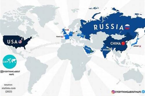
The Role of Aerial Reconnaissance in Modern Conflict Resolution
Aerial reconnaissance has increasingly become a vital component in conflict resolution, offering a unique perspective that facilitates understanding, negotiation, and peacebuilding. The use of aerial reconnaissance for conflict resolution allows for the accurate collection of data and intelligence that can be used to make informed decisions regarding military and diplomatic strategies. By providing real-time images and information, aerial reconnaissance helps to assess the severity of conflicts, monitor troop movements, and evaluate potential ceasefire agreements. Its integration into modern peacekeeping operations not only enhances transparency but also helps to build trust among conflicting parties. Furthermore, aerial reconnaissance provides a non-invasive means to survey disputed territories, reducing the likelihood of ground confrontations and promoting dialogue. This technology’s ability to gather precise and timely information supports the creation of effective resolutions that are based on factual and up-to-date data, ultimately contributing to long-lasting peace and stability.
Advantages of Aerial Reconnaissance for Conflict Resolution
1. Aerial reconnaissance for conflict resolution enables unbiased data collection without relying on subjective human accounts.
2. It provides a comprehensive overview of large geographic areas, offering insights that ground-level observation cannot achieve.
3. High-resolution imagery allows for detailed analysis, enhancing the accuracy of conflict assessments.
4. Aerial reconnaissance for conflict resolution ensures real-time monitoring, crucial for dynamic conflict situations.
5. The technology can operate in inhospitable environments where traditional surveillance is hindered.
Key Technologies in Aerial Reconnaissance for Conflict Resolution
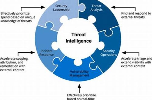
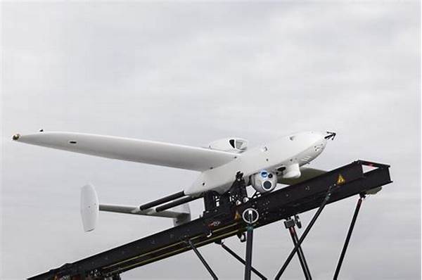
In the realm of conflict resolution, various technologies are employed in aerial reconnaissance to achieve the desired outcomes. Satellite imagery provides wide-scale observations and a basis for strategic negotiations, aiding in conflict assessments by offering a macroscopic view of disputed regions. Drones and unmanned aerial vehicles (UAVs) have introduced a new era in gathering intelligence, allowing access to remote and perilous areas without endangering human operators. These UAVs capture high-definition video and thermal imaging, which prove essential in monitoring movements and verifying ceasefire agreements. Additionally, synthetic aperture radar (SAR) is utilized to penetrate adverse weather conditions, ensuring uninterrupted data acquisition crucial for comprehensive analyses. The integration of these advanced technologies in aerial reconnaissance for conflict resolution demonstrates a significant advancement in crafting sustainable peace agreements based on accurate and up-to-date information.
Strategic Implications of Aerial Reconnaissance for Conflict Resolution
1. By employing aerial reconnaissance, conflict resolution becomes proactive rather than reactive.
2. Aerial reconnaissance for conflict resolution bridges the information gap, facilitating quicker and more informed decision-making processes.
3. It strengthens international cooperation through shared data initiatives, fostering collective efforts towards peace.
4. The strategic use of aerial reconnaissance builds confidence among conflicting parties by promoting transparency.
5. It aids in preventing further escalation by providing confirmatory intelligence on compliance with peace agreements.
6. Geospatial data from aerial reconnaissance for conflict resolution supports historical analysis, enabling a deeper understanding of conflict patterns.
7. This approach enhances border security management in conflict-prone regions, diminishing the potential for territorial disputes.
8. Aerial reconnaissance fortifies peacekeeping missions by delivering actionable intelligence, optimizing operational outcomes.
9. It aids international organizations in conflict prevention by offering timely alerts and forecasts.
10. Utilizing aerial reconnaissance for conflict resolution ensures that responses are targeted and proportionate, reducing collateral damage.
Challenges and Limitations of Aerial Reconnaissance for Conflict Resolution
Despite its many benefits, aerial reconnaissance for conflict resolution faces several challenges. The collection and interpretation of imagery require specialized skills and expertise, necessitating significant investment in training and technology. Furthermore, the ethical and privacy concerns associated with surveillance complicate its implementation, particularly in sovereign nations that may perceive such actions as intrusive or violating their autonomy. The reliance on technological systems also poses the risk of malfunction or interference, which could disrupt data collection processes. Political factors, including international treaties and jurisdictional issues, further influence the application of aerial reconnaissance. Environmental conditions, such as cloud cover and extreme weather, can limit the effectiveness and accuracy of captured data. These challenges underscore the necessity for continued advancements in technology and international cooperation to maximize the effectiveness of aerial reconnaissance for conflict resolution.
Future Prospects of Aerial Reconnaissance for Conflict Resolution
The future of aerial reconnaissance for conflict resolution holds promise as technological advancements continue to enhance capabilities and applications. The integration of artificial intelligence and machine learning will significantly improve the speed and accuracy of image analysis, allowing for more precise decision-making. Innovations in sensor technology are expected to broaden the scope and quality of data collection, capturing a wider range of observations beyond visual imaging. Furthermore, miniaturization and cost reductions of UAVs will make aerial reconnaissance more accessible and scalable, even for smaller peacekeeping missions or non-governmental organizations. Collaborations between governmental and private sectors in developing shared platforms for intelligence dissemination are likely to increase, promoting transparency and trust. As these technologies evolve, aerial reconnaissance’s role in conflict resolution will be further cemented as an indispensable tool for achieving sustainable peace and security.
Conclusion: Summarizing the Impact of Aerial Reconnaissance for Conflict Resolution
In conclusion, aerial reconnaissance for conflict resolution has emerged as a transformative tool in addressing global conflicts. Its ability to provide detailed, real-time intelligence enhances decision-making processes, contributing to more effective peacebuilding efforts. By offering comprehensive data, aerial reconnaissance facilitates strategic planning and conflict management, reducing the potential for armed escalations. Despite facing challenges such as ethical concerns and technical limitations, the ongoing advancements in technology promise to overcome these hurdles, further expanding the potential of aerial reconnaissance. As international cooperation strengthens and technological capabilities improve, aerial reconnaissance for conflict resolution will continue to play a pivotal role in fostering lasting peace and stability across the globe. Integrating these insights into diplomatic strategies not only paves the way for successful conflict resolution but also builds a foundation for sustainable global harmony.