The Significance of Aerial Data Collection in War Zones
The utilization of aerial data collection in war zones has become an essential aspect of modern military operations. This form of data collection involves the use of unmanned aerial vehicles (UAVs) and other aircraft to gather crucial intelligence. Such intelligence assists in strategic planning, threat assessment, and monitoring enemy movements. Given the complexities of contemporary warfare, the ability to obtain real-time data from difficult-to-reach areas is indispensable. Moreover, aerial data collection in war zones enhances situational awareness and enables informed decision-making processes that are vital for mission success. The increasing sophistication of technology used in these operations continually evolves, providing greater precision and reducing risks to military personnel. Subsequently, the political implications of using such technology extend beyond the battlefield, influencing broader aspects of international diplomacy and peacekeeping efforts.
Technologies Involved in Aerial Data Collection
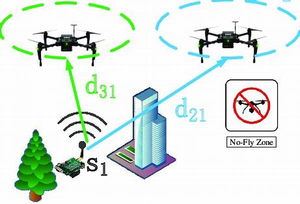
Aerial data collection in war zones employs a variety of advanced technologies. Sophisticated UAVs equipped with high-resolution cameras provide critical imagery. Satellite data enhances these operations, offering comprehensive coverage. Radar systems identify and track hostile activities with precision. Machine learning aids in data analysis, rapidly interpreting large volumes. Finally, secure communication technologies ensure encrypted data transmission, mitigating the risk of interception by adversaries.
Challenges in Implementing Aerial Data Collection
Implementing aerial data collection in war zones presents various challenges. One prominent issue is the hostile environment, which can pose threats to UAVs and hinder data acquisition. Adverse weather conditions further complicate operations by potentially disrupting signal transmissions and reducing visibility. Additionally, ensuring data accuracy can be challenging, as the fast-paced nature of conflict requires rapid data interpretation and deployment decisions. Compliance with international laws and regulations must also be maintained to avoid legal complications and diplomatic tensions. Therefore, addressing these challenges requires the integration of resilient technologies and robust operational protocols.
Ethical Considerations
The deployment of aerial data collection in war zones necessitates a thorough examination of ethical considerations. Privacy concerns arise from the surveillance capabilities of UAVs, leading to potential infringements on personal rights. The accuracy of collected data also plays a pivotal role; erroneous intelligence can result in unintended consequences during military operations. Furthermore, ethical dilemmas emerge due to the autonomous decision-making capabilities of advanced drones. Consequently, establishing comprehensive ethical frameworks and guidelines is imperative to navigate these concerns responsibly.
International Collaboration Efforts
International collaboration in aerial data collection in war zones is pivotal to addressing security challenges. Joint efforts among nations foster knowledge sharing, technological advancements, and coordinated responses to conflicts. Collaborative measures also enhance data reliability, as multiple sources contribute to a comprehensive intelligence picture. Furthermore, international partnerships support the development of standardized protocols, ensuring effective aerial data collection operations are conducted within agreed-upon ethical and legal frameworks.
Future Prospects of Aerial Data Collection
The future of aerial data collection in war zones holds significant potential for advancement. Emerging technologies, such as artificial intelligence and machine learning, offer more efficient data processing capabilities. Innovations in sensor technology enhance the precision and extent of information gathered. Additionally, increased emphasis on miniaturization could lead to the deployment of smaller, more agile UAVs capable of navigating complex terrains. These advancements promise to revolutionize intelligence-gathering methods, rendering military operations more informed and strategic.
Conclusion
In conclusion, aerial data collection in war zones represents a dynamic and evolving aspect of modern military operations. By leveraging advanced technologies, such methods provide critical intelligence that is instrumental in conducting successful missions. Despite the challenges and ethical considerations posed, international cooperation and technological innovations continue to drive progress in this domain. As future advancements unfold, the role of aerial data collection in war zones will likely expand, reinforcing its significance in global security strategies and operations. The ongoing developments underscore the importance of maintaining a balance between technological innovation, ethical guidelines, and international collaboration to ensure responsible and effective utilization of aerial data collection capabilities.